WhiteMagic Adventure Blog
Mt. Kun(7077m) Climb - Photo Story
Mt. Kun(7077m) Climb - Photo Story
We have been meaning to share our Kun climb stories with you for long but never got down to do it...so here we are now with a photo feature of the entire Kun Climb. For the past 3 years(2012, 2013 & 2014) we have been taking groups up this famed mountain in the Zanskar Region in Ladakh. Standing at 7077m, Mt.Kun along with its twin Mt. Nun(7135m) tower over the whole Zanskar Valley which abounds with mountains, most of which are virgin and have been thrown open for climbing recently by the Ministry of Tourism. Kun is one of the most popular ascents in the Zanskar Valley and sought after by climbers around the World looking to break the 7000m benchmark. The roadhead at Shafat Nallah is approached from Leh over 2 driving days via Kargil and the base camp is reached in just a day's trek from the roadhead, which makes this mountain easily accessible. We normally start off with an acclimatization trek spanning over 3 days and crossing the Kanji La(5250m) pass and ending at Rangdum. From here, we drive to the roadhead at Gulmatongas where the climbing trip begins, and over the next 15 days we try and scale the mountain and return to Leh. Here's a photo feature of the Kun Climb explained through images. Images from our previous climbs to Kun - 2012, 2013 Photo Credits: Subbu K.L. , Kuntal Joisher, Greg Leonard and WM Stock.
 Source:Indian Mountaineering Foundation(IMF) Archives
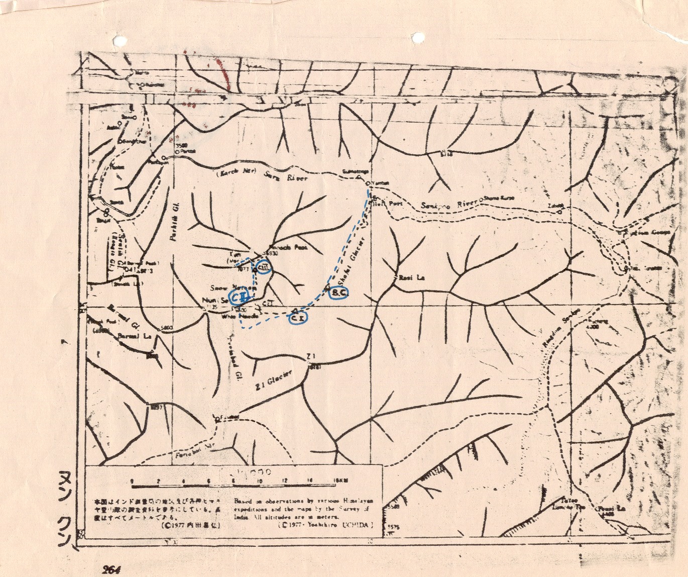
Map of Zanskar Area from IMF Archives marking the Kun Campsites and the twin peaks of NUN and KUN.  Photo Credit: Kuntal Joisher Leh, the capital of Ladakh lies in the state of Jammu & Kashmir in the north of India. It is the highest & the second largest district of India and is sandwiched between Karakoram ranges in the north & the Himalaya in the south. Ladakh really is like "Little Tibet", although being part of the India, geographically it is the western flank of the Tibetan Plateau. Today it is full of amazing sights - gompas perched on mountain tops, snow capped mountains forming scenic backgrounds, barren landscapes dotted with green oases, Colourful prayer flags fluttering in high & windy places, and friendly Ladakhi and Tibetan people.
 Photo Credit: Subbu K L
Hiking up towards Kanji La! We do a 3 day acclimatization walk over the Kanji La (5250m). This trek starts from the village Kanji & goes over the high pass of Kanji La & finishes at Rangdum. The trek offers a perfect setting to get your muscles & your body working - in a short span of 3 days we have some long walks, some serious uphills, steep descents, a few river crossings which ensures that by the time we finish the trek we are all primed up for a nice climb. The trek finishes at Rangdum, which has a few houses and a small little Gompa perched up on a hill top with some colorful rocky fold mountains forming the background.  Photo Credit: Subbu K L The third day's walk starts with an early morning river crossing of the spine chillingly cold Kanji Tokpo. The water is low in the morning but it is still quite a gushing torrent and wakes everyone up.
 Photo Credit: Subbu K L
After crossing the river we stay on the true left side of the river & climb some distance above the river floor and we suddenly see the mighty Nun Kun massif at the end of the valley.
 Photo Credit: WM Stock
Rangdum is at the head of the Suru valley & we finish the trek on the road connecting Zanskar with Kargil. At this point we have cars waiting for us to drive us 25 kms downstream to Shafat on the banks of Suru river. Shafat is a large campsite by the road & there is a bridge over the river leading into the Shafat nalla (stream which becomes quite sizeable in the summers). Apart from the bridge there are 2 govt buildings at Shafat, one a police check post which houses a few policemen in the summers and the other one housing some people from the animal husbandry department.
 Photo Credit: Subbu K L
The walk along the Shafat nalla is really fascinating. We walk in a wide grassy valley and have some seriously high mountains (many of which are unclimbed) on both sides of the valley. In the summers the bakkarwals (shepherds) from Kashmir in the south come all the way up along the Kras Nalla to the Shafat Nalla.
 Photo Credit: Kuntal Joisher
Towards the end the Shafat Nalla becomes Shafat glacier and we set up camp on the left bank of the glacier, high above the valley floor.
 Photo Credit: WM Stock
In the Shafat valley, as we turn in towards the base camp we are greeted by the sight of Mt Nun and the icy wall of the Kun which leads up to Camp 2. Most times climbers watch the route with mouths wide open, wondering how they would fare on that section. Suddenly the atmosphere changes from being a trekking trip to a climbing trip, we have some serious business ahead.
 Photo Credit: Kuntal Joisher
Base Camp is on a flat ground which has enough space to pitch 20-25 tents. There is a stream which flows close by and we have Mt Nun in the west, Fariabad glacier on the south & Z1 on the east. The campsite is nicely tucked away in the side and is normally sheltered from winds. A beautiful place which would be our home for next couple of weeks. The mules drop our loads here & head down to greener & warmer pastures. The base camp is manned by our expedition cook & his assistant while the climbers move up & down between various camps.
 Photo Credit: WM Stock
Expeditions like this are a huge logistical challenge, where we have to precisely calculate the amount of equipment, food, fuel (weight & volume) and then have a plan to move all of it to the higher camps. The sherpas do the bulk of the load ferry & fix ropes on the mountains to ensure that the camps are well stocked & the route is all ready before the clients start climbing. The clients normally do a load ferry to Camp 1 as it helps their overall acclimatization and helps the sherpas move higher to Camp 2 over the technical section.
 Photo Credit: Subbu K L
Puja ceremony at Base Camp marks the start of the expedition. We always pray for the safety & the well being of the entire team and pray for a good weather without which Climbs are rarely successful.
 Photo Credit: Kuntal Joisher
Camp 1 is a long way away from Base Camp and involves walking on glacial moraine, crossing some glacial streams and crossing the heavily crevassed area on the glacier.
 Photo Credit: WM Stock
Camp 1 - the image shows the route up to Camp 2 over the infamous ice wall on Kun. Vertical ascent is about 700m and the majority of the climb is done on fixed ropes with ascenders. This forms the crux of the climb as we reach a large plateau up on top. Camp 2 is on the edge of the plateau & Camp 3 (the summit camp) lies on the other end of the plateau.
 Photo Credit: WM Stock
Having good weather is essential for climbing up to Camp 2 and it is one of the two big days on this expedition. Most climbers are anxious on this day wondering how they would fare on the ice wall/ fixed ropes and if they would be able to move their personal loads up to Camp 2.
 Photo Credit: Manmeet Malhi
The rocky ridge in the middle of the ice wall offers a welcome break to everyone. A good time to regroup and see how everyone is doing before we set off on the second leg which is equally steep & long.
 Photo Credit: Subbu K L
Looking down towards Camp 1 (small black specks)....and the climbers ascending like Ants up the sheer ice surface.
 Photo Credit: WM Stock
Looking down south from Camp 2 where we have Zanskar range & the mountains of Kishtwar. Some of the prominent mountains in the southern skyline are Z1, Brammah I, Brammah II, Arjuna & Kiar Ri.
 Photo Credit: WM Stock
Camp 2 with Kun & Pinnacle Peak (6955m) in the background.
 Photo Credit: WM Stock
Camp 2 with Nun in the background. Being on a vast snow plateau, Camp 2 is prone to getting high winds and snow blizzards. This particular image shows Camp 2 after about 24 hrs of constant snow & high winds. Notice the amount of snow accumulation between the 2 tents, driven down by the high winds.
 Photo Credit: WM Stock
The walk from Camp 2 to Camp 3 is a short one and is on a relatively flat ground. But being fairly high (above 6000m), dragging your weight & your load up seems quite an effort. Regular breaks at short intervals are a feature of this walk.The guides let people take it easy on this day as we normally make the summit attempt on the same night (provided we have good weather).
 Photo Credit: WM Stock
A group photo just before we set off for the summit, anxious moments!
 Photo Credit: Subbu K L
Majority of the climb is done in the dark where we have nothing but the torch lights of the fellow climbers to guide us. This is peculiar of most summit nights - you have nothing to look up to, nothing to look down to. It is cold and everyone is trying to do one's best to stay focused & to keep pushing.
 Photo Credit: Subbu K L
Morning light brings in positive energy and people soon start feeling comfortable seeing each other and the sights of the summit. We have the Pinnacle Peak and the sea of low clouds in the background.
 Photo Credit: Subbu K L
Up at the summit finally - photos & picture sessions. Here we have a climber with the twin Sherpa brothers. Nun lies in the background.
 Photo Credit: WM Stock
7091m, a little higher than the geographical 7077m recorded by the Survey of India. Probably the low pressure conditions or poor calibration of the watch.
 Photo Credit: WM Stock
Another pose on the summit! We can see Nanga Parbat massif just behind the prayer flags on the centre right of the image.
 Photo Credit: Subbu K L
Group photo, prayer flags, happy faces! We did it!
 Photo Credit: WM Stock
Steep descent down to Camp 3 and now the climbers notice where they have reached. The west ridge leading up to the summit has steep drop on both sides.
 Photo Credit: Subbu K L
Looking back towards the fellow climbers coming down from the summit. The west ridge is heavily corniced on this section.
 Photo Credit: Manmeet Malhi
A photograph of people coming down from the summit taken from Camp 3.
 Photo Credit: WM Stock
Zoomed in image of Nanga Parbat taken from the snow field.
 Photo Credit: WM Stock
Winding up at Camp 3. Drying up the gear before we have a long haul down to Camp 1 or possibly to Base Camp. People are all relaxed now and have a spring in their stride after having summited a 7000+m mountain.
 Photo Credit: WM Stock
The steep descent on the ice wall from Camp 2 down to Camp 1. Excitement is high & everyone needs to go down safely on this section.
 Photo Credit: Kuntal Joisher
The last leg on the glacier between Camp 1 & Base Camp. This area is notorious for the number of crevasses, hence we need to be extremely careful here.
 Photo Credit: Subbu K L
Crossing the bridge on the Suru river, to finish the trek at Shafat . We will have cars come to pick us up.
 Photo Credit: Subbu K L
Happy moments, group photographs, handshakes, some long lasting memories, even longer lasting friendships. A journey comes to an end, time to say good bye & wishes for many more to come.
 Photo Credit: Subbu K L
Driving down towards Kargil along the Suru valley, we look back up the valley. Nun Kun Massif dominates the skyline, Kun on the left of the image, Nun on the right. We did it! We have 2 departures for Mt. Kun in 2015 guaranteed to go.
Refer our webpage for more information. Write to info@whitemagicadventure.com for details.
Add new comment